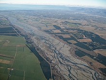
Alluvial plain
This article needs additional citations for verification. (November 2024) |


An alluvial plain is a plain (an essentially flat landform) created by the deposition of sediment over a long period by one or more rivers coming from highland regions, from which alluvial soil forms. A floodplain is part of the process, being the smaller area over which the rivers flood at a particular time. In contrast, the alluvial plain is the larger area representing the region over which the floodplains have shifted over geological time.
As the highlands erode due to weathering and water flow, the sediment from the hills is transported to the lower plain. Various creeks will carry the water further to a river, lake, bay, or ocean. As the sediments are deposited during flood conditions in the floodplain of a creek, the elevation of the floodplain will be raised. As this reduces the channel floodwater capacity, the creek will, over time, seek new, lower paths, forming a meander (a curved path). The leftover higher locations, typically natural levees at the margins of the flood channel, will be eroded by lateral stream erosion, local rainfall, and possibly wind transport if the climate is arid and does not support soil-holding grasses. These processes, over geologic time, will form the plain, a region with little relief (local changes in elevation) yet with a constant but slight slope.
The Glossary of Landform and Geologic Terms, maintained by the United States National Cooperative Soil Survey (NCSS), defines an "alluvial plain" as "a large assemblage of fluvial landforms (braided streams, terraces, etc.) that form a low gradient, regional ramps along the flanks of mountains and extend great distances from their sources (e.g., High Plains of North America)". Use of "alluvial plain" as a general, informal term for a broad flood plain or a low-gradient delta is explicitly discouraged. The NCSS glossary instead suggests "flood plain".[1]
Alluvial plains have similar traits to a river delta; however, the river delta will flow into a larger body of water. Alluvial plains generally lack this.
Examples
[edit]Americas
[edit]- Mississippi Alluvial Plain, Oxnard Plain, and Laguna de Santa Rosa in the United States[2]
- Santa Clara Valley in San Jose, California[3]
- Tempisque River plain in Costa Rica
- Middle Amazon, Brazil[4]
Asia & Oceania
[edit]- Canterbury Plains, Southland Plains, and Waikato Plains in New Zealand
- Chianan Plain in Taiwan
- Indo-Gangetic Plain and Punjab in India, Pakistan, and Bangladesh[5]
- Mekong Delta in Vietnam
- Mesopotamia in Iraq
- North China Plain in China
Europe
[edit]- Baetic Depression in Andalusia, Spain
- Lower Danubian Plain, Bulgaria and Romania
- Iskar (river) valleys in Bulgaria
- Mesaoria in Cyprus
- Multiple sites in Switzerland
- Palakaria Valley in Bulgaria
- Po Valley in Italy
- Rhine–Meuse–Scheldt in the Netherlands
- Haute vallée de la Sarthe in France
- Struma Valley in Bulgaria
- Tundzha valleys in Bulgaria
- Upper Thracian Plain in Bulgaria
See also
[edit]References
[edit]- ^ "Glossary of Landform and Geologic Terms" (PDF). National Soil Survey Handbook—Part 629. National Cooperative Soil Survey. April 2013. Retrieved 1 March 2023.
- ^ Mississippi River alluvial plain Archived 2007-07-05 at the Wayback Machine
- ^ Santa Clara Valley Groundwater Basin, East Bay Plain Subbasin Archived 2020-12-25 at the Wayback Machine
- ^ Latrubesse, Edgardo M.; Franzinelli, Elena (2002). "The Holocene alluvial plain of the middle Amazon River, Brazil". Geomorphology. 44 (3–4): 241–257. doi:10.1016/S0169-555X(01)00177-5.
- ^ Punjab Plain, Encyclopædia Britannica
2601:247:C400:5E0:B9C2:ADE9:5C57:AF41 (talk) 20:47, 3 December 2024 (UTC)[1]2601:247:C400:5E0:B9C2:ADE9:5C57:AF41 (talk) 20:47, 3 December 2024 (UTC)
- ^ ←Ĥľôŝşǣæżžźȳÿŷýŵűųŭǜǚǘūǖūǔůũüûùúťțșšşŝśřŗŕőǫŏō→
